CalWEP is making available, on special terms to CalWEP members, the WaterView™ water conservation and data management portal developed by Eagle Aerial Solutions with input from CalWEP members. This tool is custom designed to help water professionals meet the efficiency and allocation requirements established under the new long term California water conservation legislation, SB606 & AB1668.
Eagle Aerial Solutions, the portal developer, is the company that is currently conducting the statewide irrigated landscape measurement project for the California Department of Water Resources through which every residential parcel for 400+ California urban water districts is being analyzed. WaterView™ has been developed by Eagle at the request and with the input of CalWEP members to have tools and enhanced data to meet the new water conservation requirements.
WaterView™ will:
✔ Analyze total water allocation at the parcel level, in compliance with new DWR standards
✔ Help spot water use trends, track and manage over allocation users within each district, identify targeted land classifications types like high turf areas for effective rebating.
✔ Aid in upcoming DWR reporting requirements
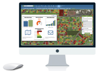
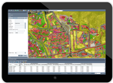
The online portal includes:
- The ability to ongoingly determine use and efficiency from parcel level to district level
- High resolution aerial imagery PLUS the ACTUAL imagery used in DWR’s study
- More detailed irrigated vegetation data than what will be provided by DWR—data that meets DWR’s precise specifications
- ET data
- More detailed demographic data for more accurate indoor water use efficiency measurements
- Parcel data and district boundaries
- GIS tools to zoom in/out, query by data (parcel, address, customer number, etc.), draw/measure, search and query by designated areas
- Ability to use in the field
- Ability to integrate water use data from your district (using our customized data loader tool)
- Other tools, functionality and data as determined by districts to be helpful